San Francisco Transit Map
After several weeks of effort and a few false starts, I present my first transit map, aimed at the casual explorer of San Francisco:
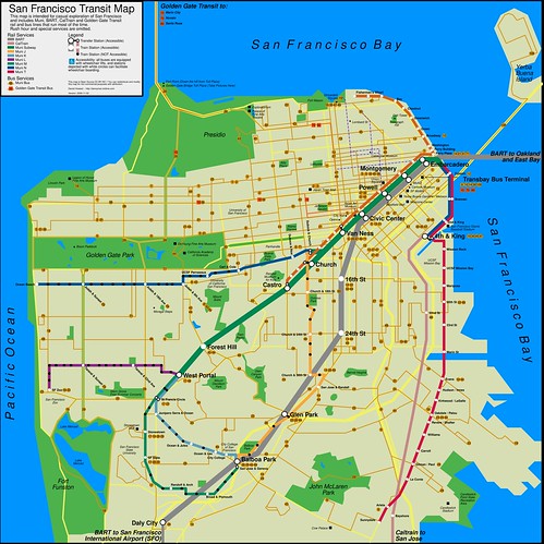
You can download the large or 360dpi version from Flickr. Or you can download the InkScape SVG source file from ratchet.
I’m not 100% happy about it, and it is lacking the SamTrans buses I wanted to add. All the same, I’m rather proud. It is train-centric but features connecting bus routes. I managed to include the three levels of rail transit on Market St by consolidating each service into its trunk lines, which let me gloss over the whole KT thing. My original ambition was to populate it with all the landmarks you wouldn’t find on your regular tourist map, but I sort of moved out of town.
Alas, I like to think that modifying info on the map should be pretty easy for others to do. The SVG file contains multiple layers that can be turned on or off, modified, add a new layer . . . you could totally create your own map based on this, if you like . . .
In selecting the size of this map, I went for a square, because despite its free-wheeling ways, San Francisco is geographically quite square, and figured to make the map 15″ x 15″ . . . if one really wanted to one could slice it in fourths and print 7.5″+ on US Letter-sized paper and voila–your own map!
If anyone finds this map useful or hacks on it, please let me know! Enjoy!
Cool link with other maps: http://www.sfcityscape.com/ — see especially the frequent service map in gif or pdf.
Response
Ellie K
It’s great! I just made a post with your map and the NYC Transit map from O’Reilly, Title is “I Love Cartography”. You did very adequate job with S.F. I’ve lived there and also NYC, and S.F. has so many public transportation varieties (BART, bus, trolleys, CalTrain etc) that it could be difficult to capture all.
Comment
Tiny Print:
<a href="" title=""> <abbr title=""> <acronym title=""> <b> <blockquote cite=""> <cite> <code> <del datetime=""> <em> <i> <q cite=""> <s> <strike> <strong>